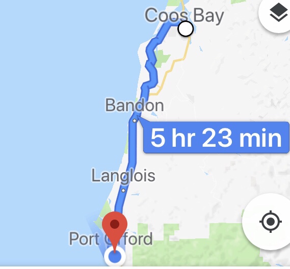
57 Miles
2221 ft of Climbing
Dear Man of My Dreams,
If you want to know the way to this girl’s heart, take her for a long walk on the beach in Brandon, Oregon.
—————–——————————
I’ll get to Bandon’s beaches later, but first, let’s talk about my morning. The first order of business was calling Garmin for help with my cycling computer. After playing around with it for an hour, the customer service rep offered to send a replacement to my next hotel stay, which will be in a mere four days. #!%?€&$ I am still working on wrapping my head around four days without my Garmin. Four days with a lot of distance and climbing. Only another Garmin owner/enthusiast could ever know my pain.
Add to that the text message I received from T-Mobile, while I was sleeping:
Free T-Mobile Msg: You’ve exhausted your data roaming allotment. Data roaming is now unavailable. Blah Blah Blah…..
What the heck! Is this some sort of conspiracy? T-Mobile’s service area is pretty much on existent, so for the next 12 days, when next billing cycle begins, I will be able to make phone calls and send text messages, but won’t be able to use data of any kind on my phone. That means no Google Maps or ability to look up the next bike shop, Wal-Mart, Ace Hardware, Dairy Queen or motel, unless I am at a McDonalds, Starbucks, motel or library (thank you Bill Gates)a with wifi. This is where I realized how dependent I am on technology to do EVERYTHING on the road
I brought up my ride on Google Maps, before leaving my cheap motel, but within a mile, the map stopped working. So now I needed to find a place with wifi to hopefully get my ride for the day up again, so I could get the turn-by-turn instructions and at least know where I am, distance-wise, in my route for the day. That worked for a couple of hours, then the map stopped working again, and I was back to no map, no Garmin, no nothing. I was suffering immensely.
But alas, I do have my paper maps with me. I have to get out my glasses to read the microscopic directions and map markings, but I have those with me too. So that is how I made it through the day. It was very painful, and it eventually got dark, but most of the day’s route followed Highway 101, and there are signs on the side of the road telling you which town you are in and the names of streets, etc., so I survived.
Break. I will now put my big girl panties on and make my best attempt to not whine further about the technical issues of this day and the next three days to come. Positive affirmations, Eileen. You will survive this moment.
So the day started out with cutting across the peninsula I stayed on, following a road that passes both McDonalds and Wal-Mart–places I needed to do business with. After making my first left turn, i was facing a hill with–well I wish I could tell you the grade, but I don’t have that data any more–a ridiculous grade. I was almost instantly standing on the pedals and putting everything I had into moving forward with my 97 lb beast of a loaded bike. That lasted for about 10 yards, before I had to put my feet down to keep from falling over. The only way I was going to make it up this hill was pushing the bike, but I couldn’t get any traction with my feet on the steeply angled road surface. They slipped and slid, and I could only take about four steps at a time, before having to stop to catch my breath. What was probably 1/10th of a mile took me over 10 minutes to climb. And that is where I realized what I whimp I am.
But once up that hill, I was back on my game. After stoping at McDonalds, where I loaded up on greasy calorie filled food, I got my map back up on Google Maps and headed for Wal-Mart. Resupplied with Gatorade and Lithium batteries for my Spot Tracker, I was back on the road.
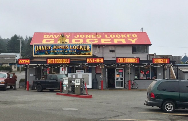
The first town I encountered was a little shipping and fishing town named Charleston. Pirates of the Caribbean has nothing on the Davy Jones Locker here.
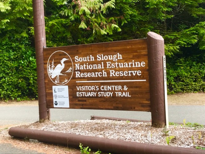
Then the ACA maps put me on a 17.5 mile spur, that took me through a super hilly forested area, where a lot of logging has been going on. I passed a National Estuarine Reserve, whatever that is, and some beautiful scenery and vistas, all while encountering very few cars. Such a treat. I would love to live near a quiet, hilly road like this, so I could train on it.
 Bandon was next on my itinerary for the day. Beyond being a cool little town, its local bike shop, South Coast Bicycles, has a good reputation. I pulled in, and Jake, the young man on duty, basically dropped everything to work on my bike. My disc brakes and derailleurs were in need of adjustment, my derailleur hanger was bent, and I needed my tubeless tires refreshed with sealant.
In the course of working on my bike, he offered me a place to stay for the night. That would have been great, but it wasn’t far enough down the road to work with my schedule, so I had to decline. I talked to him about shaving another ACA spur off my route for the day, to save miles, and he told me, “No way.” After giving me directions to the library, so I could get my map up again, he sent me on my way.
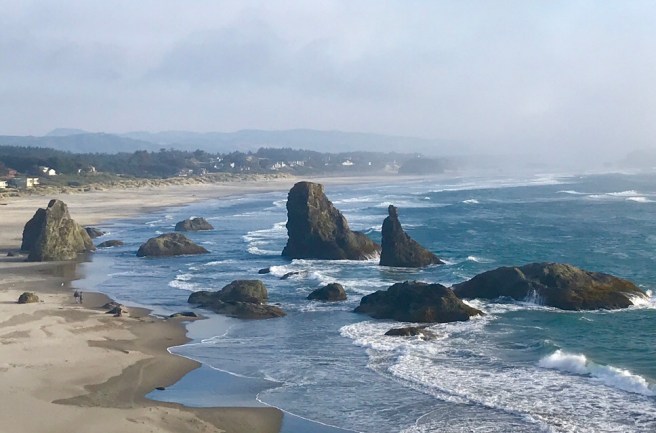
Within a mile, I was riding on Beach Loop Road, and this is just some of the scenery. Wow! It was late in the day, and I was running out of daylight, but I had to keep stopping to see these rock formations and the tide coming in. And the sandy beaches with no people on them. Breathtaking. (See paragraph one.)


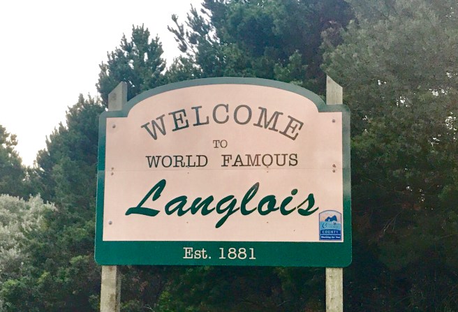
Riding out of Bandon, the sun was setting, and I still had about 28 miles to go to get to my campground for the night. Jake, the bike mechanic, lived just past World Famous Langlois, population 177, according to my map (I’ll never know what made such a small town so famous). I had already calculated the distance to my campground from there: 18 miles.
 It was now getting dark, but I have some great lights on my bike, and I actually enjoy riding at night. Arriving in Bandon just before 9 PM, I found an open grocery store with hot deli food. Dinner. I asked a gentleman in the store about the road between Bandon and my campground, and he told me that if I rode it in the dark, I would miss some of the best scenery in Oregon. So, I checked myself into another cheap motel and set myself up for a restful night in a comfy bed, with lots of wifi, a long hot shower, and time to make a couple of phone calls.
One of those phone calls was to my friend Steve Moss, who has been following my ride from Orange County. He has generously offered to send his extra iPhone to my next hotel stop. In just three days, I will have all the data I enjoy back at my fingertips. Can you believe it? Thanks Steve! You’re my hero!
Forgive the low tech map and graph below. It’s all I’ve got for three more days.


Hi Eileen. Thanks for taking the time to post today’s update. I got quite a chuckle reading about the day’s adventures. It reminds me of something I heard once about the term “adventure”. I think it was something to the efffect that adventure is only exciting when things go wrong. And it sounds like you definitely had an exciting day. Hopefully tomorrow’s adventure will be a bit less “exciting” and a lot more enjoyable. Savor the experience. Charlie
LikeLike
As I sit here using Taco Bell‘s Wi-Fi, I can say that it certainly is humbling to be without technology. I’ve had to learn to read a paper map, look for street signs, and look for any marking on the map that somehow might clue me in to where I am in relation to the map, because I have no cyclometer of any kind. It’s like the old days, before there were cyclometers and phone apps. Definitely an adventure!
LikeLike
Eileen – I was going to suggest you call T-Mobile and upgrade your plan for the month with unlimited data. You could (possibly) change your plan back after your return.
LikeLike
Catherine, thanks for the suggestion! Janette already called them. She and I Noelle the twins and Noelle‘s former partner are all on the same plan. We already have unlimited data it’s just that there’s a cap on roaming. A friend is sending me an extra phone he has, and I’ll have it tomorrow by the end of the day. In the future time will need to be more careful with using Wi-Fi when I’m downloading photos and posting my board.
What’s new in New Zealand?
Love,
Eileen
LikeLike